


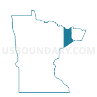
Crystal Bay P-1, Lake County, Minnesota
About
Outline

Summary
| Unique Area Identifier | 602859 |
| Name | Crystal Bay P-1 |
| County | Lake County |
| State | Minnesota |
| Area (square miles) | 210.92 |
| Land Area (square miles) | 204.83 |
| Water Area (square miles) | 6.08 |
| % of Land Area | 97.12 |
| % of Water Area | 2.88 |
| Latitude of the Internal Point | 47.62035330 |
| Longtitude of the Internal Point | -91.18693940 |
Maps


Graphs
Select a template below for downloading or customizing gragh for Crystal Bay P-1, Lake County, Minnesota


Neighbors
Neighoring Voting District (by Name) Neighboring Voting District on the Map
- Beaver Bay Twp. P-1, Lake County, MN
- Beaver Bay Twp. P-4, Lake County, MN
- Fall Lake Twp. Voting District, Lake County, MN
- Stony River Twp. Voting District, Lake County, MN
- Unorg. Terr. No. 1 Voting District, Lake County, MN
Top 10 Neighboring County Subdivision (by Population) Neighboring County Subdivision on the Map
- Fall Lake township, Lake County, MN (549)
- Beaver Bay township, Lake County, MN (473)
- Crystal Bay township, Lake County, MN (472)
- Stony River township, Lake County, MN (173)
- Lake No. 1 UT, Lake County, MN (154)